Land cover and land use change
01
Remote Sensing · ML

Land Cover & Land Use Change

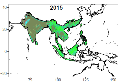
Land cover and land use change is central to global carbon budgets, environmental change assessment, agricultural planning, and conservation measures. We use novel machine learning and deep learning algorithms to improve the accuracy of LCLU data across the globe and subsequently detect its changes over time.

The LCLUC patterns, rates, and transitions identified in our studies provide a valuable resource for downstream climate and environmental research, from quantifying carbon emissions to evaluating policy effectiveness.

Deep Learning MODIS Landsat AVHRR Change Detection
Climate and land interaction
02
Climate · Land

LCLUC–Atmosphere Interaction

Climate variability and extremes result from a combination of internal variability, greenhouse gas emissions, and other forcings, including land cover and land use change. However, how these different forcings compare in magnitude is not yet sufficiently understood or quantified.

We leverage LCLUC datasets derived from remotely-sensed data and apply robust statistical methods and climate models to attribute the causes of climate variability and extremes, with a focus on temperature and precipitation extremes across regional to continental scales.

Mean Climate Climate Extremes Earth System Models Attribution Biogeophysics
Agricultural sustainability
03
Agriculture · Food

Agricultural Sustainability

The United Nations Sustainable Development Goals highlight the necessity of reducing poverty, advancing social equity, and ensuring environmental protection simultaneously. Precision agriculture offers a promising pathway toward these goals.

We utilize multi-source satellite and UAV imagery to identify cropland dynamics, crop diseases, crop health and phenology, soil moisture, and the effectiveness of irrigation and agricultural aid. Our work spans from the Arkansas Delta to sub-Saharan Africa.

Crop Phenology Crop disease Irrigation UAV Imagery Satellite Imagery
Air quality and human health
04
Health · GIS

Air Quality & Human Health

Human health is deeply vulnerable to environmental change, including degraded air quality and emerging infectious diseases. We use geospatial methods to reveal natural and socioeconomic drivers of various diseases to predict disease risk areas and improve prevention efforts.

We also use satellite-derived air quality data, including ammonia, aerosol optical depth, and fine particulate matter, to explore relationships between environmental conditions and public health outcomes across spatial scales.

Ammonia Aerosol Optical Depth COVID-19 maternal mortality Spatial modeling

Projects

Ongoing Projects

NASA 01/2025–12/2027

Forecasting Mosquito-Borne Disease Risk in a Changing Climate: Integrating GLOBE Citizen Science and NASA Earth System Modeling

Role: Co-PI  ·  NASA ROSES

Finished Projects

NASA 07/2023–07/2025

Quantifying Effects of Land Cover Change–Climate Interactions on Ecosystem Productivity in Northwestern US

Role: PI  ·  NASA EPSCoR R3

NASA 2022-2023

Onboard computing systems for remote sensing spatio-temporal environmental data streams

Role: Co-PI  ·  NASA EPSCoR RID

AR INBRE 05/2022-08/2022

Identifying the effects of climatic and socioeconomic variables on the spread of COVID-19 in Arkansas using geospatial techniques

Role: PI  ·  Arkansas IDeA Network of Biomedical Research Excellence

ASGC 01/2022-01/2023

Spatiotemporal Patterns of Soybean Phenology in the Northern Arkansas Delta Region

Role: PI  ·  Arkansas Space Grant Consortium

ASGC 01/2022-01/2023

Landscape-Scale Restoration of Fire-Adapted Vegetation in the Ouachita Mountains

Role: Co-PI  ·  Arkansas Space Grant Consortium

NASA 02/2021–02/2022

Quantifying Irrigation Impacts on Crop Yield in the Arkansas Delta

Role: PI  ·  NASA EPSCoR RID

Microsoft 01/2021–01/2022

Assessing net ecosystem carbon exchange for the conterminous United States with MODIS Data and machine/deep learning models

Role: Co-PI  ·  Microsoft Azure computation credit grant